I think it’s fair to say that the Bosphorus is the maritime counterpart of Istiklal Caddesi – it’s one of the busiest ‘streets’ in Istanbul. Or should I say the world, since it’s the second busiest strait on the planet. On average 48,000 vessels per year transit between the Sea of Marmara and the Black Sea by using this Istanbul strait – a narrow ‘S-shaped’ complex natural channel with several sharp turns and headlands, which prevent a proper overview, and with changing currents. That’s 132 vessels per day, not including local traffic consisting of public transportation ferries, Bosphorus cruises and fishing boats.
Bosphorus Facts & History
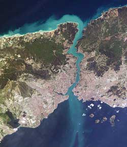
The Bosphorus (İstanbul Boğazı) is the northeastern strait of the Sea of Marmara, which connects this inner sea with the Black Sea. Even today there is still a lot of speculation about the origin of the Bosphorus.
One recent theory (published in 1997 by William Ryan and Walter Pitman from Columbia University) contends that the Bosporus was formed about 5600 B.C. when the rising waters of the Mediterranean/Sea of Marmara breached through to the Black Sea, which at the time (according to the theory) was a low-lying body of fresh water. Yanko-Hombach, a geology professor of Odessa State University, Ukraine, claims that the water flow through the Bosporus repeatedly reversed direction over geological time depending on the relative water levels of the Aegean Sea and the Black Sea. This contradicts the proposed catastrophic breakage of a Bosporus sill on which Ryan and Pitman base their hypothesis. Undoubtedly to be continued.

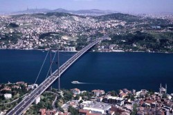
The first Bosphorus bridge in Istanbul.
What we do know are the following facts about Bosphorus. It is 32 km long, with a maximum width of 3,700 m at the northern entrance, and a minimum width of 700 m between Kandilli and Aşiyan and 750 m between Anadoluhisarı and Rumelihisarı. The depth changes from 36 to 124 m in midstream.
Two bridges connect the European and the Asian continents. The first bridge over the Bosphorus is simply called the Bosphorus Bridge (Boğaziçi Köprüsü), measures 1074 meters and was completed in 1973. The second bridge (1090 meters long) was completed in 1988, and is called the Fatih Sultan Mehmet Bridge (Fatih Sultan Mehmet Köprüsü). Locals also refer to the bridges as the first and the second bridge.
Bosphorus Mansions (yalı)

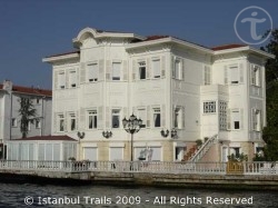
A mansion (yalı) on the shores of the Bosphorus in Istanbul, Turkey.
The shores of Bosphorus have always been the city’s most favorite locations for settlements. The trademark of the Bosphorus is the yalı – a house or mansion constructed at the immediate waterside (almost exclusively seaside) in Istanbul. More than 600 finely worked wood constructions, mostly in the style of traditional Turkish houses, are lined next to one another and make the Bosphorus tour a treat for your eyes. The oldest surviving yalı is the one built by the grand vizier Amcazade Köprülü Hüseyin Pasha (of the highly influent Köprülü family) in 1699 in the Kanlıca district, on the Asian shores of the Bosphorus. The most expensive yalı is ‘Erbilgin Yalısı‘ located in Yeniköy, Istanbul. Forbes magazine listed ‘Erbilgin Yalısı‘ as the fifth most expensive house in the world with a price tag of $100 million.
On the surface of the Bosphorus the current usually flows from the Black Sea towards the Sea of Marmara. However, at a certain dept, the current flows in the exact opposite direction.
Strategic Importance
The Bosphorus has a huge strategic importance, both economical and military. In recent history alone, twice has the control over the Istanbul strait been at stake: in the Russo–Turkish War (1877–1878) and during World War I when in 1915 Allied Forces attacked the Dardanelles.
Currently, according to the Montreux Convention Regarding the Regime of the Turkish Straits of July 1936, the Bosphorus is treated as an international shipping lane, but Turkey does retain the right to restrict the naval traffic of non-Black Sea nations.

Comments on this entry are closed.